 Orbit
Receiver image
Loading archiveLoading the latest archived image…
—
Live reception
Times reflect when the station reported each milestone.
Capture of the Week
Explore clouds, coastline, and interrupted scan lines in an image received by the Manila ground station.
Latest capture
Loading the latest reception…
The people behind Orbit
We’re Adriel, Eliazar, and Jude Vincent — third-year Bachelor of Science in Computer Science students at the Polytechnic University of the Philippines–Manila.
We’re taking part in the 2026 Satellite Observation Data Utilization Contest by the WNI WxBUNKA Foundation. Orbit is our window into that work: receiving weather satellite signals from Metro Manila, decoding them into images, and sharing what we observe.
Explore our research
BS Computer Science · Third year

BS Computer Science · Third year

BS Computer Science · Third year
What we want to understand
We aim to obtain and analyze weather satellite images of cloud cover over Luzon, with a focus on weather systems approaching from the east. We compare cloud patterns on either side of the Sierra Madre with separate rainfall estimates and wind data to explore where they agree, where they differ, and what the images can tell us.
Cloud cover alone does not measure rainfall. Our study keeps reception gaps, uncertainty, and the limits of each comparison visible.
Loading receptions…
Capture dates in Manila time
No captures match. Try another satellite or date.
Loading reception stories…
6 November 2026 · Meteor M2-4 and Himawari-9
Look for Luzon below the central gap. The black bands show missing scan rows.
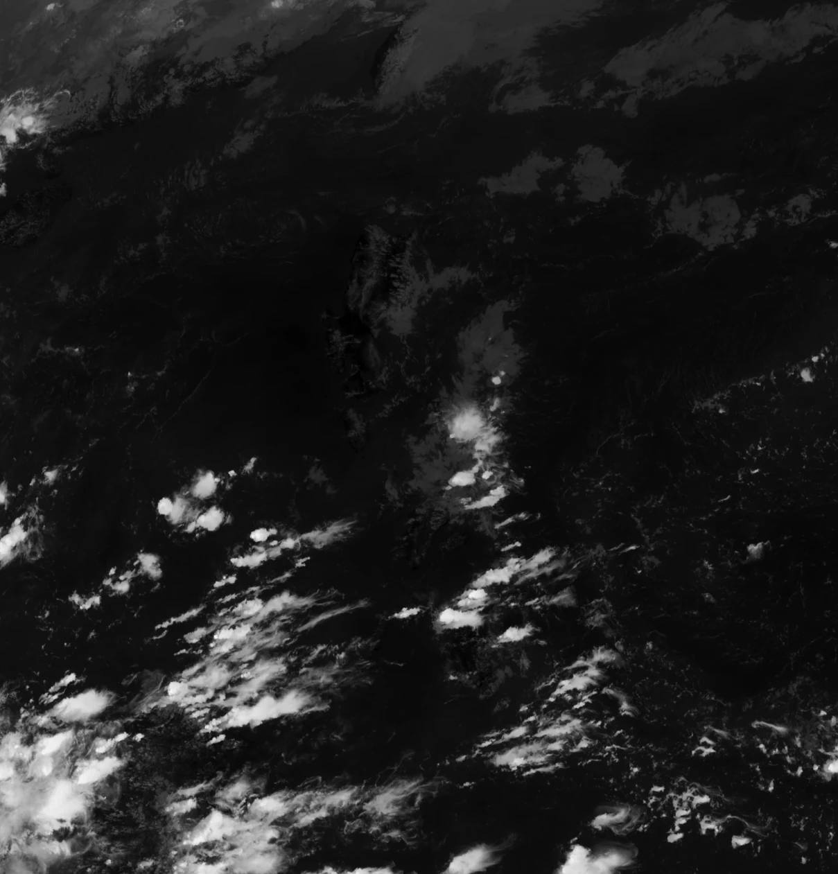
Look for the cloud field east of the Philippines. Brighter areas show lower brightness temperatures in this rendering.
using Himawari’s nominal scan time. Use recognizable features to orient yourself. The images have different projections and channels, and pixel alignment is unverified.
Himawari source files and processing ↗15 November 2026 · Meteor M2-3 · 137.9 MHz
Frequency offset from 137.9 MHz · Relative power

Eight seconds of recorded I/Q played at one-fifth speed. The cursor follows the same time in the waterfall.
Processing notes ↗First archived CADU · 1,024 bytes
1A CF FC 1D 40 05 15 F7 54 00 00 00 00 54 00 95
1C 00 00 FF F0 5D FC 30 C7 3C 73 8E A3 14 60 12
The highlighted four bytes are the expected sync marker. The decoder uses it to identify the start of a channel access data unit (CADU).
Download the 220 archived CADUs ↓
Pass Watch
Metro Manila station telemetry
Loading the latest archived image…
40° minimum peak · Manila time
Loading today’s passes…
How Orbit handles a pass over the Metro Manila station.
Receives the satellite’s VHF broadcast.
Samples the received signal as I/Q.
Records the pass and decodes image frames. Selected recordings can be reprocessed on the Mac.
Publishes image products, decoded frames, and available reception logs.
Calculating…
| Satellite | Date · PHT | Acquisition | Peak elevation | Loss of signal | Duration | Actions |
|---|
Horizon events use a 10° mask; the filter applies to maximum elevation. Passes are predictions, not scheduled recordings.
Waiting for fresh orbital predictions
Arrows show direction of travel. Rings mark where each satellite would appear at least 10° above the local horizon.
Loading orbital data…
Our study examines cloud and rainfall estimates across fixed areas in Nueva Ecija and Aurora.
Project members ↓Compare rainfall-depth estimates in the western and eastern study boxes. Start with the 17 September 2026 case, 16:00 UTC.
East minus west · millimetres
| Product | West | East | Difference |
|---|
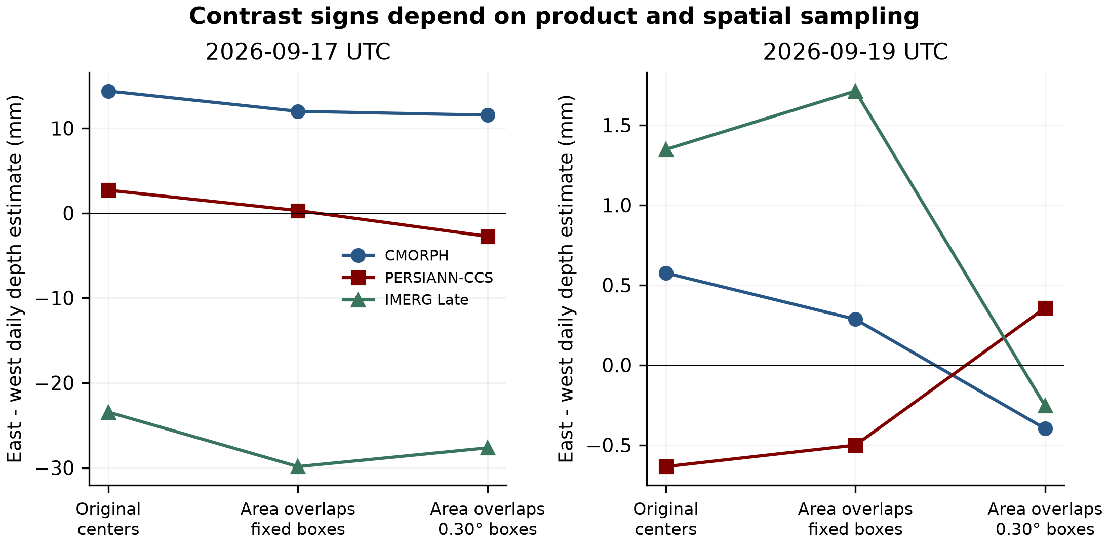
Weighting rainfall cells by their overlap with the same study boxes removes three-product east-greater agreement from all four original wet-hour cases. October follow-ups retain null results and opposing estimates. Cloud occupancy alone cannot resolve these rainfall contrasts.
Six audited receptions on 4–6 November demonstrate our antenna-to-image pipeline. Missing bands remain visible. These November observations do not enlarge the September weather sample; image pixel registration remains unverified.
48 original September snapshots, all 72 fixed-date October snapshots, and three separately conditioned follow-ups. Provider geolocation supports these measurements; neither pixels nor hours count as independent storms.
All 96 original IMERG Late Run files are preserved and hash-checked. Offline replay verifies 144 box/hour records and 2,736 base/shift records. The base sampling uses one western and two eastern native cells, limiting fine-scale interpretation.
We now weight each native rainfall cell by its spherical overlap with the fixed study box. None of the four original September wet-hour contrasts is east-greater in all three area-weighted products. At 16:00 UTC on 17 September, IMERG changes from +0.585 mm with cell centers to −0.170 mm with area overlaps. Expanded 0.30° boxes provide a separate sensitivity check.
| Date (UTC) | Product | Difference |
|---|---|---|
| 2026-09-17 | CMORPH | +11.99 |
| 2026-09-17 | PERSIANN-CCS | +0.30 |
| 2026-09-17 | IMERG Late | -29.86 |
| 2026-09-19 | CMORPH | +0.29 |
| 2026-09-19 | PERSIANN-CCS | -0.50 |
| 2026-09-19 | IMERG Late | +1.71 |
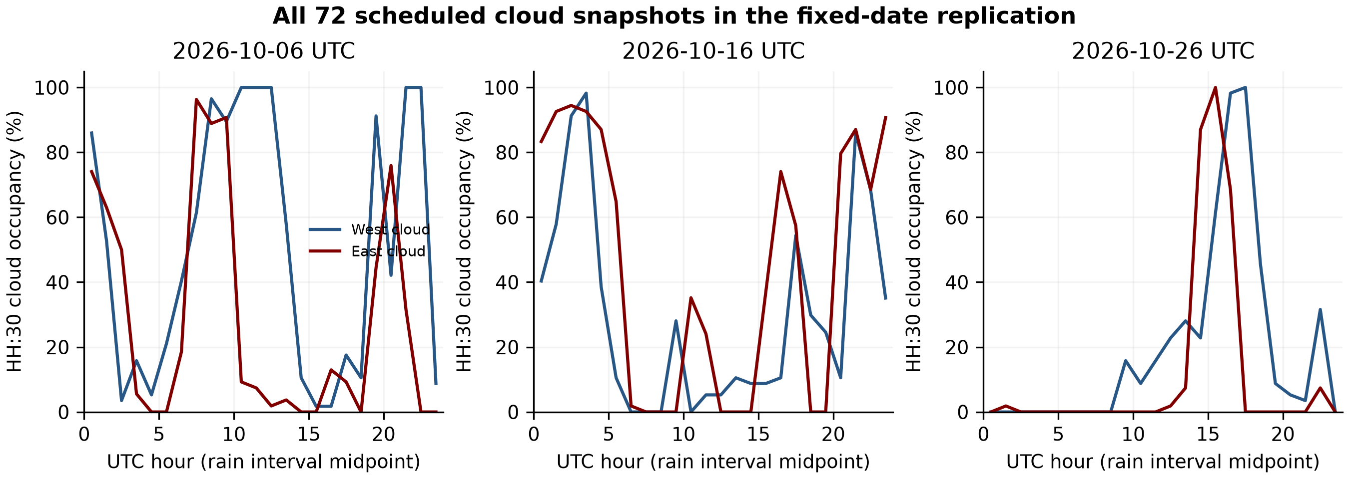
Fixed October 6, 16 and 26 checks include all 72 cloud snapshots and 68 complete two-product rain-hour comparisons. All 37 easterly hours have rain data, but none meets the qualifying east-greater wet criterion. Four October 26 CMORPH source containers are empty and remain missing, never dry.
A separately declared October screen retains all 124 candidates at 00, 06, 12 and 18 UTC. Three wet/easterly hours qualify on October 11–12: two have opposing product signs. The concordant October 12 case has 98.2% western and 100% eastern cloud occupancy, so complete saturation is not universal. These adjacent-date cases do not establish independent-storm replication; IMERG was not retrieved for them.
Local projection checks have not established independent landmark accuracy. No suitable in-box gauge record was obtained from the audited public station sources. Local quantitative geography, ground validation, author/adviser review and organizer clarification remain open.
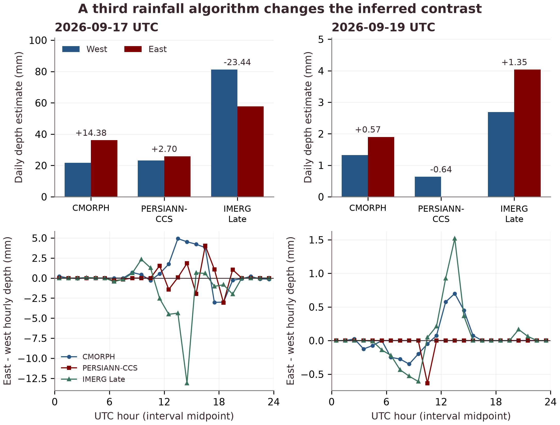
In the historical cell-center extension, IMERG reverses three of four originally concordant wet-hour contrasts. No daily east–west contrast sign is shared by all three algorithms on either date. IMERG estimates more western rainfall on 17 September, opposite to both original algorithms. Products have different spatial support and can share inputs; no one estimate is treated as ground truth.
| Date | Algorithm | West | East | East − west |
|---|---|---|---|---|
| 17 Sep | CMORPH | 21.75 | 36.12 | +14.38 |
| 17 Sep | PERSIANN-CCS | 23.15 | 25.84 | +2.70 |
| 17 Sep | IMERG Late | 81.23 | 57.79 | -23.44 |
| 19 Sep | CMORPH | 1.32 | 1.90 | +0.57 |
| 19 Sep | PERSIANN-CCS | 0.64 | 0.00 | -0.64 |
| 19 Sep | IMERG Late | 2.69 | 4.04 | +1.35 |
Swipe the table to see all columns.
CMORPH/PERSIANN placement robustness does not extend to all three algorithms. IMERG is Late Run, with V07C filenames and a 07B internal version field, not Final Run. The terrain-model control severely underestimates rainfall; terrain-caused enhancement is not established. These remain two weather dates.
Received-scan timing is checked before any orbit segment is drawn.
Blue line: satellite subtrack for time-checked scans. Amber ring: approximate station region. No image footprint or geographic image overlay is asserted.
Select an observation.
Original CADUs and processing logs remain intact. This portal copies selected evidence without changing the source archive. Raw IQ is retained separately on the Pi where documented.
Count complete 1024-byte records, distinct records, expected sync markers, and trailing bytes. SHA-256 hashes connect each download to its archived source.
Decoded products can contain missing lines. Colour composites are variants of the same observation. Geographic overlays are withheld pending scan-time validation.
Loading archive verification policy…
Download manifest ↗